Saturday, December 15, 2012

Sunshine Coast


This was a trip that was the antithesis of Murphy's Law, where everything that could have gone wrong went right. Rah Rah & I headed to Canada for some sunshine and warm water and found it! We travelled to Lund, BC - the gateway to Desolation Sound and the beginning of Highway 101. The seas there were 1 to 2 foot chop so we launched our kayak in the sheltered waters of Okeover Inlet. We paddled toward Desolation Sound with the wind and current at our backs.
View from our campsite at Feather Cove on north end of Malaspina Peninsula

We exited Okeover and found a pleasant campsite. The makeshift toilet was set back in the deep, dark woods and looked like it would be more at home on the set of Deliverance. I didn't linger long enough to take a photo.

The next morning the wind and current continued at our backs as we paddled toward Prideaux Haven. We bypassed the Curme Islands which are the most popular kayak camping area in Desolation Sound as they aren't suitable for yacht anchorage.  
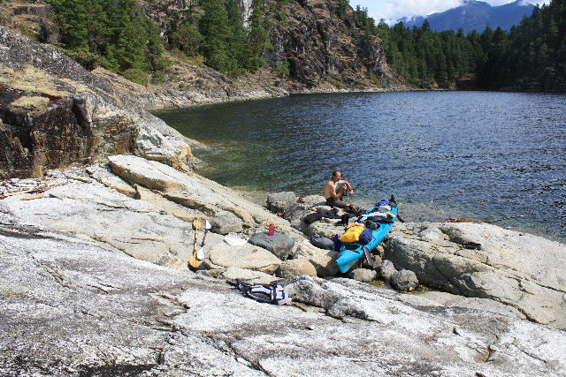
Lunch near Bold Head after rock ledge landing. Easy landings are scarce in Desolation Sound. Typical is rock ledge, gravel and rock and oyster beds if desperate. Ouch!
We arrived in early afternoon at Melville Island and found the campfire still smoldering but no people were around. We set up camp and for the next two nights had this beautiful spot to ourselves, excepting for the seals who came to bask on a nearby ledge. 
Melville Island, campsite at edge of trees.
View from Melville Island
We got up with the sun the next morning to explore the nooks and crannies of Prideaux Haven. Most of the nooks and crannies were inhabited by yachters but we discovered a shallow, boatless bay to have lunch. We also discovered that yachters aren't early risers so it was very peaceful gliding past these RV's of the sea. By late morning the yachters did come alive and we got a glimpse of how the other half lives with float planes flying in supplies to anchored yachts.
Prideaux Haven
Bay at Copplestone Island
Back in camp at Melville Island we lounged around in the sun and watched the seals and later enjoyed the sunset.

On our return the next day we headed over to Curme Islands to see what we had missed by not camping there. We circumnavigated the islands at low tide and checked out the sea stars. There were several friendly kayak parties camped on the scenic islands. From the vertical topography, it didn't appear the groups on one of the islands would be leaving until high tide.


We headed to Tenedos Bay and did the short hike into Unwin Lake. A dip in the freshwater lake was enjoyably refreshing. A long paddle brought us back to Okeover Inlet.
Looking back at Desolation Sound before entering Okeover Inlet.
It was HOT in Okeover and we were tired so we paddled leisurely and spied out sea stars along Coode Peninsula. Day was receding as we arrived at the Okeover Wharf so we felt fortunate that sites were available at the nearby campground.
Government Wharf in Okeover Inlet - our boatpacking trip was over.
The next day our luck continued when we caught the ferry from Saltery Bay to Earls Cove just in the nick of time. Roger wanted to get to the wild and crazy Skookumchuck Narrows at peak viewing time. I requested we make a brief stop at an attractive park with a nice view of Vancouver Island. So we did. When we got to the ferry landing, it appeared we would be waiting for the next ferry - scheduled 3 hours later. The ferry was almost full, they were loading cars one at a time, and there were several cars in front of us! Oh Crap! I had caused Roger to miss Skookumchuck at full power. But no - the ferry workers were magicians and we were loaded! A nice Canadian couple came over and commented how relieved I looked to make the boat!
View that almost caused us to miss the ferry.
After witnessing the rapids of Skookumchuck Narrows, we went to Porpoise Bay Provincial Park looking for a campsite and got the last one! Porpoise Bay is a popular family park with one of the rare sandy beaches in the area. (Travel tip: I think the whirlpools created by the outgoing tide at Skookumchuck are even more phenomenal than the waves created by the incoming tide.)

Gazing out at the calm waters of the Strait of Georgia the next morning left us in a quandary. The water was soooo inviting but the forecast was for rough seas and wind in the afternoon. After a local commented that the crossing to Thormanby wasn't that far, we launched our kayak from Halfmoon Bay and headed for South Thormanby Island. We landed in a bay just north of Dennis Head which, on this day, was absolutely idyllic. 
Small bay north of Dennis Head, South Thormanby Island
We decided to explore an old farmstead site which was a short hike away. It was summer weather and we hadn't seen anyone else, so Roger went hiking in his underwear only. I was wearing long pants but only had on a jog bra on top. As we neared a beaver pond we saw movement. It was 2 other people! We've reached an age where we really don't want to pollute the visual world by wearing skimpy attire but our clothes were back at the bay. We forged ahead and ended up having a long chat with a couple of kayak enthusiasts from nearby Roberts Creek. 

Back at the bay it was so nice we lamented the fact that we hadn't loaded our camping gear. So we paddled on, enjoying seals, ducks, eagles, turkey vultures, and South Thormanby's coastline. It was late afternoon when we had to cross back over Welcome Passage to Halfmoon Bay and, our good fortune continuing, the forecasted wind had never materialized. We headed back with slack tide, "seas calm".
Surprisingly calm waters of Welcome Passage
It was hard to leave the Sunshine Coast after such a delightful day but we left for the mountains near Whistler. We found a nice campsite at Nairn Falls and a good bakery just north of there in Pemberton. (Pemberton also has public showers.) 

Our first day hike, brutal but beautiful, was Joffre Lakes.The trail to the first lake is short and easy but after that the trail climbs relentlessly up roots and boulders. The pay-off is worth it.
Third Joffrey Lake
Second Joffrey Lake
Our second day hike, easier but longer, was into Garibaldi Lake. The hike is through forest to an absolutely stunning lake, backed by glaciated mountains. Continuing on the lakeshore trail brought us to views of little, picturesque islands gracing the lake. Despite the glacier fed water, a popular pastime was to swim out to the islands.
Garibaldi Lake
Garibaldi Lake
We did the tourist thing at Whistler and took the Peak 2 Peak Gondola which spans Whistler and Blackcomb. We felt like we were cheating getting a ride up to the views from Whistler Peak and the alpine trials of Blackcomb Mt. 
Black Tusk from Whistler Peak
Next on our itinerary was to return to the U.S. and head for the Mt. Baker area. We didn't want to try and find a campsite near Mt. Baker on a Saturday night so we decided to have a "bonus" day in Canada. We headed to Birkenhead Lake with our kayak and were rewarded with water smooth as glass and warm enough to swim in. Motorized boats are allowed on the lake but not many were buzzing about so the paddle was quite leisurely and peaceful. 
Birkenhead Lake
Heading toward Mt. Baker I consulted the map and suggested that we take the Sumas border crossing. A few miles from the border we saw a sign that said the border crossing closed at 5pm. We had less than 10 minutes to make it to the border and were faced with traffic and stoplights. Could we be lucky one more time? Yes! We arrived at 5:05 and sailed on through.

We listened to the next day's forecast for Seattle which called for clouds in the morning and clearing in the afternoon so we figured the weather at Mt. Baker would be pretty iffy. We awoke in the morning to pretty heavy cloud cover so we selected the Cougar Divide trail. It is relatively easy, culminating in a flowery ridge walk with good views of Mt. Baker and Mt. Shuksan. Even if we didn't get the views we could enjoy the flowers. We got out of our car at the trailhead and were attacked by a horde of Zombie mosquitoes. It was still cloudy. Had our good fortune deserted us on our last vacation day? We lathered on mosquito lotion and headed out. By the time we broke out onto the ridge meadow the mosquitoes and clouds were gone! What a fabulous way to end a perfect journey.


Mt. Shuksan from Cougar Divide
Mt. Baker
What a time. What a place.


No comments: